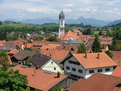
Pfronten is a municipality in the Ostallgäu district of Bavaria, in Germany, on the northern edge of the Allgäu Alps. The Vils river flows through its territory. The municipality is made up of the districts of Bergpfronten and Steinachpfronten, and its many villages have formed a single parish since the late Middle Ages. Its highest point is the Aggenstein, on the Tyrolean border.
Pfronten is in Bavaria, Germany, and has a population of about 7,890.
Why go to Pfronten?
Pfronten sits where the northern Allgäu Alps meet the Tyrolean border. The Aggenstein, the municipality's highest point at 1986 metres above sea level, lies on the frontier and belongs to the Tannheim Mountains. The Vils runs through the municipal land, which takes in the villages of the 13-village community of Pfronten. Neighbours include the city of Füssen and the market of Nesselwang. On the Austrian side, the Tannheim valley lies close by, with the communities of Grän and Tannheim.
When is the best time to visit Pfronten?
July and August are the warmest, with highs of about 20 °C, and January is the coolest, at about 1 °C. January, February and December are the time for skiing. For nature and hiking trips, go in June, July and August.
How do I get to Pfronten without flying?
From 4 destinations you can travel to Pfronten directly by bus or train. Counting connections, 2,404 destinations can reach it within 14 hours without flying. Travelling from Reutte, allow 22 min by train with DB Regio AG Bayern; that is about 0.2 kg of CO₂ per person. From Nesselwang, it takes 6 min by train with DB Regio AG Bayern, with about 0.1 kg of CO₂ per person. The bus from Grän takes 1h 06m; that is about 0.3 kg of CO₂ per person.
What to do in Pfronten
Aggenstein
The summit that is the municipality's highest point, on the Tyrolean border in the Tannheim Mountains.
Tannheim valley
A valley in Austria, close to Pfronten, with the communities of Grän, Tannheim, Schattwald and Zöblen.